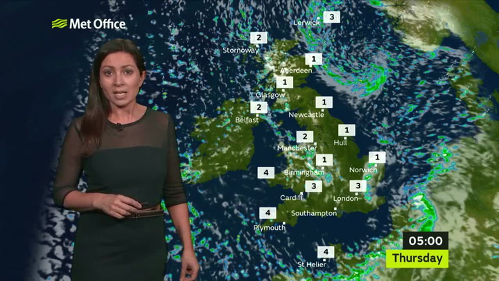
Commuters are being warned to wrap up warm with icy conditions due to take hold on Wednesday night (January 31).
It precedes a period of sustained cold weather, according to the Met Office.
A yellow warning for ice has been issued for between 6pm on Wednesday and 10am on Thursday (February 1). The warning covers all of London as well as much of the UK.
It is also predicted there will be bursts of rain on Wednesday evening and in the early hours of Thursday.
News you might have missed


Forecasters say there is a high chance that in the clear skies to follow, the temperature will plummet and water on the ground will turn to ice.
The Met Office has also issued a yellow warning for snow in Scotland during the same period, but it is unlikely snow will fall in southern England.
Looking further ahead, the cold spell is expected to continue.
Cold temperatures could lead to frost on Friday morning (February 1) and it could return in the evening.
Forecasters are predicting a wet weekend, but temperatures will struggle to get above 6C, while clear skies on Sunday night (February 2) means commuters are likely to wake up to frost next Monday morning.
It will turn milder for most of the UK next week, but the cold spell is predicted to stay in the south-east of England, with highs of 5C and the temperature falling below zero at night.

Keep up to date with the latest news in west London via the free getwestlondon app.
You can set up your app to see all the latest news and events from your area, plus receive push notifications for breaking news.
Available to download from the App Store or Google Play for Android .