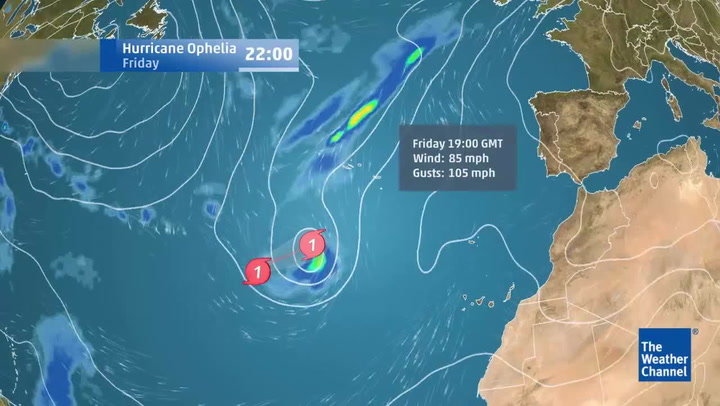
Hurricane Ophelia, the 10th consecutive Atlantic storm to become a hurricane in 2017, is heading for the UK this weekend .
Britain could be in for a breezy time as dramatic satellite footage shows how Ophelia will travel "very quickly" northwards this weekend - but we could still experience temperatures in the mid-20Cs .
Although the storm will become an "ex-hurricane" by the time it reaches the UK, it will still bring fierce winds and heavy rain in many places.
The latest update predicts the storm will reach Britain on Monday (October 16) via Portugal before sweeping north east to UK shores.
Weather and environment news


Currently drifting around the Atlantic Ocean, the weather map shows it could hit on what will be the 30th anniversary of the so-called "Great Storm" .
The Great Storm of 1987, famously dismissed by BBC weatherman Michael Fish, hit the UK over October 15-16. Some 22 people died across the country and in Europe.
However, by Monday, Ophelia will have left tropical waters behind, so is unlikely to still be a "hurricane" at that stage, forecasters say.
But the speed of movement shown in the footage demonstrates it will still hold a lot of rain and wind.

Ahead of Ophelia's arrival, the footage shows warm weather will arrive on Saturday and Sunday - and temperatures could reach the twenties.
In fact, temperatures in southern and eastern England could be hit 23C, some six degrees above normal, according to The Mirror .
Due to a separate band of low pressure, unsettled weather is expected going into Tuesday, and conditions will remain changeable throughout the rest of the week.
The West of England is expected to be worst-hit by its remnants, with heavy rain and winds of 60-70mph.
What's the weather going to be like in London this weekend?
It will be dry and warm on Saturday (October 14) but still generally cloudy, with some brighter spells possible in the east.
Cloud may thicken to give an odd spot of rain by the evening, with maximum temperatures of around 20C.
Sunday (October 15) will also be mainly dry and warm with variable cloud and some sunny spells.
Forecasters are predicting it to be bright and very warm with sunny spells in London on Monday (October 16), turning windy.
Strong winds at first on Tuesday October 17, before turning dry and bright.

Keep up to date with the latest news in west London via the free getwestlondon app.
You can set up your app to see all the latest news and events from your area, plus receive push notifications for breaking news.
Available to download from the App Store or Google Play for Android .